Wednesday, 24 February 2016
|
Wednesday, 24 February 2016
|
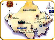 Rajasthan
is located in the northwestern part of the subcontinent. It is bounded on the
west and northwest by Pakistan, on the north and northeast by the states of
Punjab, Haryana, and Uttar Pradesh, on the east and southeast by the states
of Uttar Prad esh and Madhya Pradesh, and on the southwest by the state of Gujarat.
The Tropic of Cancer passes through its southern tip in the Banswara district.
The state has an area of 132,140 square miles (342,239 square kilometres).
The capital city is Jaipur.
Rajasthan
is located in the northwestern part of the subcontinent. It is bounded on the
west and northwest by Pakistan, on the north and northeast by the states of
Punjab, Haryana, and Uttar Pradesh, on the east and southeast by the states
of Uttar Prad esh and Madhya Pradesh, and on the southwest by the state of Gujarat.
The Tropic of Cancer passes through its southern tip in the Banswara district.
The state has an area of 132,140 square miles (342,239 square kilometres).
The capital city is Jaipur. |
|
||||